February 3, 2025 3:40 a.m.
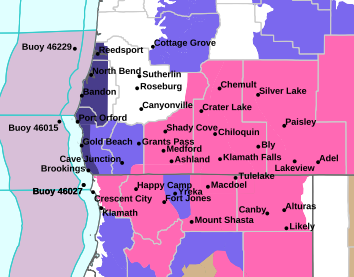
A Winter Storm Warning remains in effect through 10:00 p.m. Monday for mountain areas in much of southern Oregon.
Forecasters at the National Weather Service said an atmospheric river and stationary front will continue to bring impactful weather to the region through Monday. The snowfall accumulation will be unusually high east of the Cascades and over the Siskiyou Summit through this event. Snow will continue to accumulate into Tuesday, although the locations, intensity and elevations will change.
Heavy snow is expected on Monday with additional accumulations of between 8 and 16 inches.
The Warning area includes the southern Oregon Cascades and Siskiyou Mountains. This applies to the Siskiyou Summit on Interstate 5, Mt. Ashland, Lake of the Woods and Crater Lake. The highest totals are anticipated towards the Oregon/California border.
Forecasters said travel could be very difficult to impossible. People should delay traveling if possible. If travel is absolutely necessary, drive with extreme caution and be prepared for sudden changes in visibility.
Listen to News Radio 93-9 FM and 1240 KQEN and check www.541radio.com to stay connected with updated weather information.