November 11, 2020 9:30 a.m.
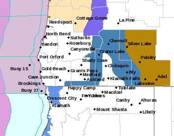
A Winter Weather Watch is in effect for mountain areas in southern Oregon from late Thursday night through late Friday night above 5,000 feet.
Forecasters at the National Weather Service a potent storm system is expected to move into the area Friday and Friday night. Heavy snow and strong winds are forecast. The snow combined with the winds could cause tree damage and bring whiteout conditions at times.
Total accumulations of ten to twenty inches are possible in some locations, with wind gusts of 50 to 70 miles per hour possible.
The Storm Watch area includes Crater Lake, Diamond Lake and the Southern Oregon Cascades and Siskiyou Mountains. Forecasters said travel could be very difficult to impossible. Very strong winds could cause extensive tree damage and reduced visibility to below one quarter of a mile at times. Blowing and drifting snow is also possible.
Forecasters said residents should plan now to avoid traveling during the storm.