January 18, 2024 1:50 p.m.
The National Weather Service has issued a Flood Potential Outlook for parts of southern Oregon.
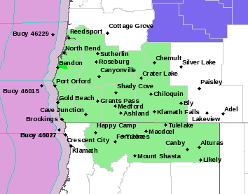
Forecasters at the National Weather Service said snow melt flooding, quick rises of streams and creeks to near bank full, and ponding of low-lying areas as well as poorly draining urban areas is forecast for Douglas, Coos, Curry, Josephine and Jackson counties.
Forecasters said a long duration atmospheric river event is expected to bring 1 to 5 inches of rain to the region from Friday night through Monday morning. Rainfall amounts are expected to be highest in Josephine and Curry counties. However, a melt-able snow pack, raises the risk for more widespread flooding. As well as flooding concerns, this rainfall could also lead to increased occurrences of rockfall and localized landslides.
The exact scenario for flooding along rivers and streams remains uncertain. Watches and warnings may be issued by the National Weather Service if the situation worsens.
Listen to News Radio 93-9 FM and 1240 KQEN and check www.541radio.com to stay connected with updated weather information.