January 13, 2024 6:15 a.m.
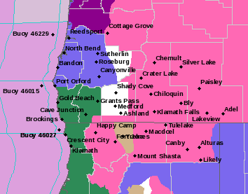
A Winter Storm Warning remains in effect until Saturday night at 10:00 p.m. for mountain areas in parts of southern Oregon.
Forecasters at the National Weather Service said heavy mixed precipitation with snow as well as periods of sleet and a rain-snow mix are expected. Additional snow accumulations of up to 24 inches and ice accumulations of a light glaze. Winds gusting as high as 50 miles per hour over exposed terrain and frequent blowing snow causing reduced visibility.
The Warning area includes the south central and southern Oregon Cascades and higher portions of the Siskiyou Mountains. This includes Diamond Lake Junction, Crater Lake and Lake of the Woods. It applies to highways 62, 138, 230, 58 and 140 in the Cascades.
Forecasters said travel could be very difficult to impossible due to snow and a wintry mix. For the latest road conditions, go to www.tripcheck.com.