March 13, 2025 4:10 a.m.
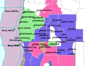
The National Weather Service has issued a Flood Potential Outlook for rapid rises from rain and snow melting on rivers and streams in Douglas, Josephine, Jackson, Coos and Curry counties.
Forecasters said an active storm track will remain over the region through at least early next week. An upper trough and showery pattern are in place for Thursday with another frontal system moving into the area on Friday. This will be followed by a moist, atmospheric river system late Saturday into Sunday. Each of these systems is expected to bring snow and wind impacts to portions of the area. The fluctuating precipitation and snow levels means that some recently accumulated snow will be melted by the heavy rainfall causing an increased runoff.
Forecasters said river levels are expected to rise, especially for rivers and streams west of the Cascades, Sunday into Monday as heavy rain moves into western portions of the area. The most recent river forecast predicts flood stage to be reached by Saturday night on Deer Creek near Roseburg and by Sunday night on the Rogue River near Agness. Other rivers and streams will see large rises that could be dangerous to anyone near water.
A Flood Potential Outlook is issued when there is the potential for significant rises and flooding along rivers and streams.
The National Weather Service in Medford told News Radio 93-9 FM and 1240 KQEN that the Roseburg area is forecast to see nearly three inches of rain between Friday and Sunday, with two inches expected on Sunday alone.
The Roseburg Regional Airport recorded 0.87 inches of rain on Wednesday. The afternoon high temperature was 51 degrees.
Listen to News Radio 93-9 FM and 1240 KQEN and check www.541radio.com to stay connected with updated weather information.