January 8, 2024 3:45 a.m.
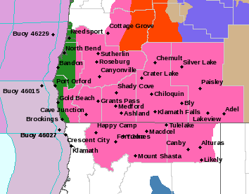
A Winter Storm Warning remains in effect from 1:00 a.m. Tuesday through 4:00 p.m. Wednesday for higher elevations in parts of the region.
Forecasters at the National Weather Service said heavy snow and blowing snow is expected above 2,000 feet. Total snow accumulations of up to 12 inches, with up to 24 inches possible over the highest terrain. Winds will gust as high as 55 miles per hour.
The Warning area includes the foothills of the Cascades, Siskiyou and Klamath mountains in Douglas, Jackson and eastern Curry counties. It also applies to the Tiller-Trail Highway and portions of Interstate 5 and highways 62 and 140 above 2,000 feet.
Travel could be very difficult to impossible. Blowing snow could cause whiteout conditions. The hazardous conditions could impact the morning or evening commute.
Significant winter weather impacts are also possible for all the Interstate 5 passes between Grants Pass and Canyonville if snow levels are only 100 to 200 feet lower than expected. The most likely time for this to occur will be Wednesday morning and Wednesday evening.
Forecasters said travel is strongly discouraged because of dangerous conditions. Those who must travel should keep tire chains, a flashlight, blankets, food, water, medications, and a fully charged phone with them.
Listen to News Radio 93-9 FM and 1240 KQEN and check www.541radio.com to stay connected with updated weather information.