
December 10, 2021 4:20 a.m.
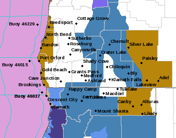
Heavy snowfall is possible in mountain areas of southern Oregon Saturday through Tuesday.
Forecasters at the National Weather Service said a Winter Storm Watch is in effect from Saturday morning through Sunday afternoon above 3,500 feet.
Forecasters said a series of wet and cold low-pressure systems will move across the region. New snow accumulations of 12 to 24 inches are possible. Winds of 40 to 60 miles per hour across the passes and higher elevations are expected at times.
The Watch includes the Southern Oregon Cascades and Siskiyou Mountains including portions of highways 138, 230, and 62 in the Diamond Lake and Crater Lake areas.
Travel could be very difficult to impossible during this time period. Patchy blowing snow could significantly reduce visibility. Gusty winds and heavy snow could cause tree damage. Travel is likely to be impacted on Interstate 5 going over the Siskiyou’s.
Stay with News Radio 1240 KQEN and check www.541radio.com for updates on this pending weather situation.