January 9, 2024 3:45 a.m.
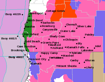
A Winter Storm Warning remains in effect through 4:00 p.m. Wednesday for areas above 2,000 feet in a wide section of the region.
Forecasters at the National Weather Service said heavy and blowing snow is expected above 2,000 feet. Total snow accumulations of up to 12 inches, with up to 24 inches possible over the highest terrain. Winds gusting as high as 55 miles per hour.
The Warning area includes the foothills of the Cascade, Siskiyou, and the high terrain of the Kalmiopsis wilderness mountains in Douglas, Jackson and eastern Curry counties. It applies to the Tiller-Trail Highway and portions of Interstate 5 and highways 62 and 140 above 2,000 feet.
Forecasters said travel could be very difficult to impossible. Patchy blowing snow could significantly reduce visibility. The hazardous conditions could impact the morning or evening commute. Gusty winds could bring down tree branches.
Snow accumulations in the valleys will be tricky and much will depend on the intensity of precipitation that comes in later Tuesday night into Wednesday morning.
Listen to News Radio 93-9 FM and 1240 KQEN and check www.541radio.com to stay connected with updated weather information.