January 6, 2024 6:00 a.m.
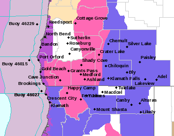
A Winter Storm Warning remains in effect through 10:00 pm. Saturday for mountain areas in southern Oregon.
Forecasters at the National Weather Service said large snow accumulations of 8 to 16 inches are expected, with local amounts up to 20 inches. Winds will gust as high as 40 miles per hour.
The Warning area includes the south central and southern Oregon Cascades and Siskiyou Mountains. It applies to Diamond Lake, Crater Lake, Union Creek and all major passes along Interstate 5 and highways 66,140, 62, 138, 230, and 58.
Forecasters said heavy snow and low visibilities due to blowing snow will result in hazardous travel conditions. Snowfall rates of 1 inch per hour will occur along the Cascades and in portions of the Siskiyou’s through 12:00 p.m. There is also a 50 to 70 percent chance of snowfall rates exceeding 2 inches per hour during the same time period.
Travel is strongly discouraged because of dangerous conditions. Those who must travel should keep a flashlight, blankets, food, water, medications and a full charged phone with them.
A Winter Storm Warning means that severe weather is likely and poses a threat to life and property.
Listen to News Radio 93-9 FM and 1240 KQEN and check www.541radio.com to stay connected with updated weather information.