January 4, 2024 4:00 a.m.
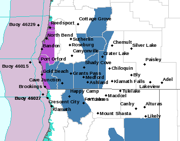
A Winter Storm Watch is in effect from early Saturday morning through Saturday evening for mountain areas in parts of southern Oregon.
Forecasters at the National Weather Service said heavy snow is possible with total snow accumulations of between 6 and 12 inches. West winds could gust as high as 35 miles per hour.
The Watch area includes the south central and southern Oregon Cascades and Siskiyou Mountains including Crater Lake, Diamond Lake and the Siskiyou Summit. Affected highways include portions of routes 58, 230, 62, 140, 66, and Interstate 5.
Forecasters said drivers should plan on slippery road conditions. The heaviest snow is likely to occur between 7:00 a.m. and 2:00 p.m. on Saturday. Lower snow levels will accompany additional lighter snow showers later Saturday night through Sunday afternoon.
Motorists should stock an emergency kit with tire chains, a flashlight, batteries, blankets, food, water and medications.
A Winter Storm Watch means there is potential for significant snow accumulations that may create dangerous travel conditions.
Listen to News Radio 93-9 FM and 1240 KQEN and check www.541radio.com to stay connected with updated weather information.