February 21, 2023 4:05 a.m.
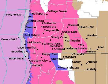
A Winter Storm Warning remains in effect from 10:00 a.m. Tuesday through 10:00 a.m. Wednesday above 1,500 feet while a Winter Weather Advisory is in place starting at 4:00 p.m. Tuesday through 10:00 a.m. Wednesday above 500 feet for central Douglas County and much of southern Oregon.
Forecasters at the National Weather Service said moderate to heavy snow is expected above 1,500 feet. Total snow accumulations of 3 to 6 inches with up to 12 inches above 3,000 feet are expected. Winds are forecast to gust as high as 45 miles per hour over the higher terrain. Above 500 feet, 1 to 3 inches are expected with winds gusting up to 35 miles per hour.
Most areas will experience some degree of winter weather impacts. For the Warning area, this includes Interstate 5 passes, but especially those between Canyonville and Glendale, along with Highway 42 at Camas Mountain, Highway 227 south of Tiller and the foothills within Douglas County. For the Advisory area, this includes the rest of Interstate 5, highways 42 and 138 and the cities of Roseburg and Sutherlin.
Forecasters said travel could be very difficult to impossible above 1,500 feet. Patchy blowing snow could significantly reduce visibility. Hazardous conditions could impact the morning and evening commutes.
Snow levels will lower to around 2,000 feet by Tuesday morning, and continue to lower to 1,500 feet by Tuesday afternoon. They will then likely reach the valley floors near or above 500 feet Tuesday night.
Travel is strongly discouraged due to dangerous conditions. Those who must travel should keep tire chains, a flashlight, blankets, food, water, medications, and a fully charged phone with them.
Listen to News Radio 93-9 FM and 1240 KQEN and check www.541radio.com to stay connected with updated winter weather information.