February 11, 2023 3:40 p.m.
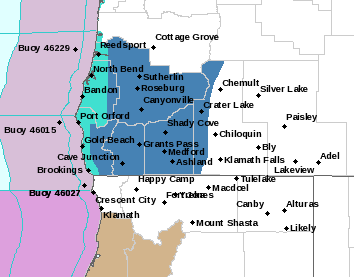
A Winter Storm Watch is in effect from Monday morning through Tuesday afternoon above 1,500 feet for much of the region.
Forecasters at the National Weather Service said heavy snow is possible above 1,500 feet. Total snow accumulations of 2 to 5 inches are possible over populated and traveled areas with up to 12 inches possible over high remote terrain. Winds could gust as high as 35 miles per hour over exposed high terrain.
The Watch area includes central Douglas County, Josephine and Jackson counties and eastern Curry County.
Forecasters said travel could be very difficult.
Snow is expected on the valley floors. Most of the snow will fall around Monday night along and behind the second cold front.
Those who must travel should stock an emergency kit with tire chains, flashlights, batteries, blankets, food, water and medications. Forecasters say plan now to avoid traveling during the storm.
A Winter Storm Watch means there is potential for significant snow accumulations that may create dangerous travel.
Stay with News Radio 93-9 FM and 1240 KQEN and check www.541radio.com to stay connected with updated weather information.