December 25, 2022 6:30 a.m.
A High Wind Watch is in effect from Monday evening through Tuesday Evening.
Forecasters at the National Weather Service said south winds of 35 to 45 miles per hour with gusts up to 80 miles per hour are possible.
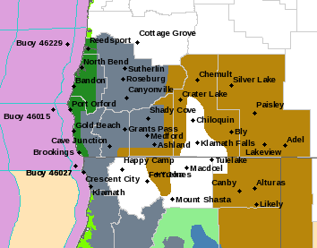
The Advisory area applies to the south central and southern Oregon Cascades and the Siskiyou Mountains. That includes Crater Lake and Mt. Ashland.
Forecasters said damaging winds could blow down trees and power lines. Power outages will be possible. Travel could be difficult, especially for high profile vehicles.
Snow levels will lower around 7:00 a.m. Tuesday to where heavy, wet snow is falling at the rate of one inch per hour. That is very likely to cause white out conditions, which would severely restrict visibility. The combination of heavy snow and strong winds will also increase the chance for trees to fall.
Check back for updates on this situation. Dangerous driving conditions are possible. Fasten loose objects or shelter objects in a safe location prior to the onset of winds.
Stay with News Radio 93-9 FM and 1240 KQEN and check www.541radio.com to stay connected with updated information on the High Wind Watch.