December 23, 2021 4:30 p.m.
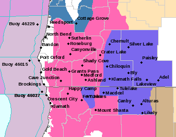
A Winter Storm Warning remains in effect from 4:00 a.m. Friday to 12:00 p.m. on Monday above 1,500 feet for central Douglas County and nearby areas.
Forecasters at the National Weather Service said periods of moderate to heavy snow is expected above 1,500 feet on Friday. New snow accumulations of 3 to 6 inches are forecast between 1,500 and 2,500 feet from Friday through Saturday morning. 6 to 18 inches is likely above 2,500 feet during that same time period. Additional heavy snow is expected Saturday afternoon through Monday morning with up to 12 inches between the 1,500 to 2,000 feet elevation, to as much as 2 to 3 feet at higher elevations. Winds could bust between 20 and 40 miles per hour at exposed higher elevation locations.
The Warning also applies to Josephine County and eastern Curry County including portions of Interstate 5 between Grants Pass and Tri-City, portions of Highway 199 in the Illinois Valley, portions of the Tiller Highway from near Tiller to Shady Cove and the Camas Mountain area on Highway 42.
Forecasters said travel could be very difficult to impossible. Patchy blowing snow could significantly reduce visibility.
The warning period will bring times of significant snowfall from multiple waves of low pressure moving into the area. Expect heavy snowfall to begin to impact the Canyon Mountain and Sexton Summit passes on Friday. Snow may lighten on Saturday morning then increase late that morning into Saturday night and Sunday.
Stay with News Radio 1240 KQEN and check www.541radio.com for updates on the winter weather situation.