
November 26, 2022 6:00 a.m.
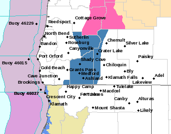
A Winter Storm Watch is in effect from Sunday evening through Monday afternoon above 2,500 feet in the eastern Douglas County foothills, south central and southern Oregon Cascades, Siskiyou Mountains and Jackson County.
Forecasters at the National Weather Service said heavy snow and blowing snow is possible. Total accumulations of 3 to 8 inches are forecast, with up to a foot over higher peaks and ridges. Winds could gust as high as 50 miles per hour.
The Watch area includes Crater Lake, Diamond Lake and Toketee Falls. Forecasters said travel could be very difficult due to snow covered roads and low visibility. Gusty winds could bring down tree branches. The heaviest snow is expected late Sunday night into Monday morning and could produce snowfall rates of 1 inch per hour during the Monday morning commute.
Forecasters said people should plan now to avoid traveling during the storm. A Winter Storm Watch means there is potential for significant snow, with accumulations that may create dangerous travel conditions.
Stay with News Radio 93-9 FM and 1240 KQEN and check www.541radio.com to stay connected with the latest weather information.