July 20, 2024 6:20 a.m.
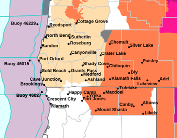
A Fire Weather Watch is in effect for most of southern Oregon from 5:00 p.m. Saturday through 8:00 a.m. Sunday.
Forecasters at the National Weather Service said an upper-level low will move up from the south along the California coast late Saturday afternoon and will tap into increasing mid-level moisture. Meanwhile, elevated instability will increase, and this combined with a moderate to strong trigger could result in isolated to scattered thunderstorms late Saturday evening into Sunday morning and again Sunday afternoon and evening. Given how dry fuels are, along with continued hot temperatures, lightning efficiency will be high to very high for fire starts.
The Watch areas includes the Umpqua Basin, Umpqua National Forest, Southern Oregon Coast, Southern Oregon Cascades and surrounding areas.
Lightning strikes outside of precipitation cores are possible and cause for concern. Outflow winds with gusts up to 40 miles per hour are forecast. These outflow winds can travel up to 50 miles away from the thunderstorm that caused it.
A Fire Weather Watch means that critical fire weather conditions are possible during the valid watch time. These conditions could promote the rapid spread of wildfires which could become life-threatening.
Listen to News Radio 93-9 FM and 1240 KQEN and check www.541radio.com to stay connected with updated weather information.

