January 26, 2024 3:50 a.m.
Quick rises and potential flooding along streams and creeks and ponding of low-lying and poorly drained urban streams are possible in parts of southern Oregon through Saturday.
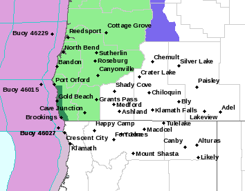
The National Weather Service has issued a Flood Potential Outlook for western Douglas and western Josephine counties and for Coos and Curry County
Forecasters said a front will stall along the southern Oregon coast Friday through Saturday, producing a prolonged period of moderate to heavy rain, potentially exceeding 6 inches in some areas over a period of less than 24 hours. The heaviest rain is expected in central and southern Curry County Friday afternoon through Saturday morning.
With soils already mostly saturated, this period of heavy rainfall could result in flooding along area waterways, along with ponding of low lying and poorly drained urban areas. As well as flooding concerns, this rainfall could also lead to increased occurrences of rockfalls and landslides.
Forecasters said the exact scenario for flooding remains uncertain. Watches and warnings may be issued by the National Weather Service if the situation worsens.
Listen to News Radio 93-9 FM and 1240 KQEN and check www.541radio.com to stay connected with updated weather information.