
December 1, 2023 4:10 a.m.
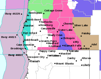
A Winter Storm Warning remains in effect until 10:00 p.m. Saturday for the south central and southern Oregon Cascades and Siskiyou Mountains.
Forecasters at the National Weather Service said heavy snow with areas of blowing snow is expected. Total snow accumulations of 8 to 35 inches are forecast with winds gusting as high as 45 miles per hour.
The Warning area is for locations above 4,500 feet including Diamond Lake, Crater Lake, Willamette Pass and highways 230, 62 and 138 in the high Cascades.
Forecasters said travel could be very difficult to impossible. Patchy blowing snow could significantly reduce visibility. Gusty winds could bring down tree branches.
Snow will accumulate down to 3,500 feet in the Cascades before snow levels gradually rise into Saturday. 3 to 6 inches of snow are forecast for the Siskiyou Mountains.
Travel is strongly discouraged due to dangerous conditions. Those who must travel should keep tire chains, a flashlight, blankets, food, water, medications, and a fully charged phone with them. Motorists should check current travel conditions at www.tripcheck.com
Listen to News Radio 93-9 FM and 1240 KQEN and check www.541radio.com to stay connected with updated weather information.