
November 29, 2023 3:50 a.m.
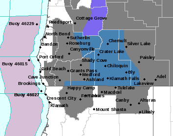
A Winter Storm Watch remains in effect for mountain areas in the region from Thursday afternoon through Saturday Afternoon above 4,000 feet.
Forecasters at the National Weather Service said there is potential for heavy snow above 4,000 feet. Total snow accumulations of 1 to 2 feet are possible. Winds could gust as high as 35 miles per hour over exposed terrain.
The Watch area includes the southern Oregon Cascades and Siskiyou Mountains including Crater Lake, Diamond Lake and the eastern Douglas County foothills.
Forecasters said travel could be very difficult to impossible over 5,500 feet. Snow accumulations will primarily fall in two rounds Thursday evening and Friday night. Snow could continue through Sunday as a warm front approaches the region. Snow levels will likely rise up to 7,000 feet by Monday evening.
Drivers should check road conditions at www.tripcheck.com.