
January 6, 2026 3:50 a.m.
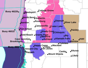
A Winter Storm Warning is in effect from 4:00 p.m. Tuesday through 10:00 a.m. Thursday for mountain areas in parts of southern Oregon.
Forecasters at the National Weather Service in Medford said heavy snow is expected above 3,500 feet from Tuesday evening through Wednesday morning. Heavy snow is expected to resume from Wednesday afternoon to Thursday morning. Total snow accumulations of 4 to 10 inches from Tuesday evening to Wednesday morning. Then an additional 8 to 20 inches in the Cascades and 3 to 8 inches in the Siskiyou Mountains Wednesday afternoon to Thursday morning. Winds gusting as high as 50 miles per hour over high and exposed terrain during both events.
The Warning area includes the southern Oregon Cascades and Siskiyou Mountains including Diamond Lake, Crater Lake, Lake of the Woods, and Siskiyou Summit along with highways 138, 230, 140, 62 down to Union Creek, 66 and Interstate 5.
Forecasters said road or highway closures are possible. Gusty winds could bring down tree branches. Those who must travel should keep an extra flashlight, food and water in their vehicle in case of an emergency. Call 511 or visit www.tripcheck.com for road information.