March 14, 2025 4:00 a.m.
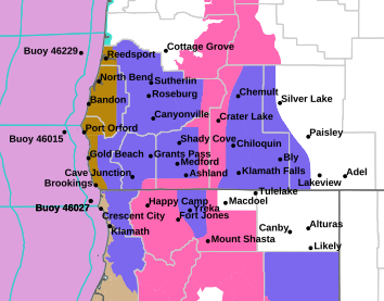
A Winter Storm Warning remains in effect through 11:00 p.m. Sunday for mountain areas in parts of southern Oregon.
Forecasters at the National Weather Service said heavy snow is expected. Total snow accumulations ranging from 1 to 2 feet, except 2 to 4 feet above 5,000 feet north of Highway 140. Winds are forecast to gust between 50 and 60 miles per hour.
The Warning area includes the south central and southern Oregon Cascades and Siskiyou Mountains. It applies to Lake of the Woods, Crater and Diamond lakes, as well as highways 140, 62, 230, and 138.
Forecasters said visibilities may drop below one quarter mile due to falling and blowing snow. Travel could be very difficult to impossible. Whiteout conditions are possible and will make travel treacherous and potentially life-threatening. This is most likely Saturday night into Sunday. Strong winds could cause tree damage and power outages.
Snowfall rates could reach 1 inch per hour on Friday.
Those who must travel should keep an extra flashlight, food and water in their vehicle in case of an emergency. Call 511 or visit tripcheck.com for road information.
Listen to News Radio 93-9 FM and 1240 KQEN and check www.541radio.com to stay connected with updated weather information.