March 15, 2025 1:45 p.m.
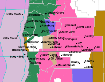
A Flood Watch is in effect from late Saturday afternoon through Sunday evening for much of western Oregon.
Forecasters at the National Weather Service said an active storm track will remain through at least early next week. Light to moderate precipitation through Saturday will cause only minor rises. However, a moist, atmospheric river late Saturday into Sunday will bring periods of very heavy rainfall to the watch area. Rain amounts of 3 to 6 inches are likely during this time frame for the coast, and coast ranges with 1 to 3 inches in the Umpqua Basin and Rogue Valley. Snow levels will rise this weekend to around 5,000 to 5,500 feet by Sunday and this will lead to some snow melting and increased runoff.
The Watch area includes central Douglas County and its eastern foothills, Josephine and Jackson counties, eastern Curry County, and the south-central Oregon coast.
Forecasters said excessive runoff may result in flooding of rivers, creeks, streams, and other low-lying and flood-prone locations. Creeks and steams may rise out of their banks. Flooding may occur in poor drainage and urban areas.
Residents should monitor later forecasts and be alert for possible flood warnings. Those living in areas prone to flooding should be prepared to take action should flooding develop.
A Flood Watch continues for Deer Creek at Roseburg between Sunday morning and early Monday morning. At 11.5 feet, water begins to cover Southeast Douglas Avenue west of Dawson Road. The flood stage is 10.0 feet and may be reached based on the latest forecast information.