February 12, 2025 4:00 a.m.
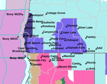
A Winter Weather Advisory remains in effect from 1:00 a.m. Thursday to 1:00 a.m. Friday for mountain areas in parts of southern Oregon.
Forecasters at the National Weather Service said snow is expected. Total snow accumulations of between 6 and 12 inches are forecast. Winds will gust as high as 55 miles per hour.
The Advisory area includes the southern Oregon Cascades and Siskiyou Mountains. It applies to areas from Lake of the Woods northward and higher portions of the Siskiyou Mountains west of Interstate 5, including the Mt. Ashland ski road, and portions of highways 230, 62 and 140.
Forecasters said travel could be difficult to impossible. The hazardous conditions could impact the Thursday morning and evening commutes. Gusty winds could bring down tree branches.
The heaviest snowfall accumulations are expected near Diamond Lake and Crater Lake, especially Thursday morning and again Thursday evening through Friday morning.
Drivers should slow down and use caution while traveling. Call 511 or visit www.tripcheck.com for road information.
Listen to News Radio 93-9 FM and 1240 KQEN and check www.541radio.com to stay connected with updated weather information.