December 24, 2024 4:10 a.m.
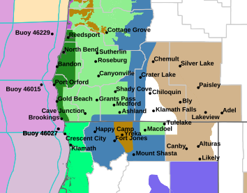
The National Weather Service has issued a Flood Potential Outlook for significant rises on rivers, creeks and streams, and possible main stem river flooding due to multiple periods of moderate to heavy rain in much of southern Oregon.
The Flood Potential Outlook includes Douglas, Jackson, Josephine and Coos Counties.
Forecasters said a series of wet frontal systems will produce periods of moderate to heavy precipitation Wednesday night through this weekend. Significant rises are expected late this week, but especially Saturday night into early next week. 5-day precipitation totals of 2 to 5 inches are possible over west side valleys, with 5 to 10 inches possible in the mountains and along the coast. This rainfall will increase the risk for both flash flooding, especially over area burn scars, as well as small stream and river flooding.
Forecasters said watches and warnings may be issued if this situation worsens.
Listen to News Radio 93-9 FM and 1240 KQEN and check www.541radio.com to stay connected with updated weather information.

