
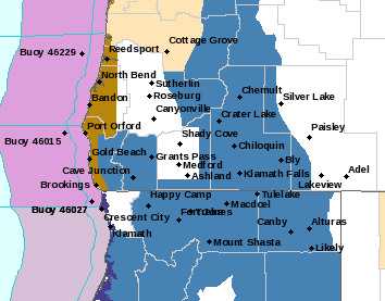
November 29, 2022 4:00 a.m.
A Winter Storm Watch remains in effect from Wednesday morning through Thursday afternoon for the south-central Oregon Cascades and Siskiyou Mountains including Diamond Lake and the Siskiyou Summit.
Forecasters at the National Weather Service said heavy snow is possible with total accumulations of 10 to 20 inches possible. Winds are slated to gust from 30 to 50 miles per hour over exposed higher terrain. This includes Interstate 5 near the Siskiyou Summit and portions of highways 62, 66, 138, 140 and 230.
Forecasters said travel could be very difficult to impossible. Patchy blowing snow could significantly reduce visibility. Gusty winds could bring down tree branches. The heaviest snow is expected between Wednesday evening and Thursday morning.
Drivers should slow down and allow extra time to reach their destination. Carry tire chains and be prepared for snow covered roads and limited visibilities. Periods of snow are expected to cause travel difficulties.
Stay with News Radio 93-9 FM and 1240 KQEN and check www.541radio.com to stay connected with weather information.