
December 23, 2021 4:20 a.m.
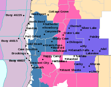
A Winter Storm Watch is in effect from Friday morning through Monday morning above 1,500 feet for much of Douglas County and surrounding areas.
Forecasters at the National Weather Service said periods of moderate to heavy snowfall is possible. Total snow accumulations of several inches at lower elevations to as much as a few feet near the 3,500-foot level are forecast.
The Watch area includes central Douglas County, the eastern Douglas County foothills, Josephine and Jackson counties and eastern Curry County, including Glendale, Steamboat, and Toketee Falls. Portions of Interstate 5 between Grants Pass and Tri-City, the Tiller Highway from near Tiller to Shady Cove, and Highway 138 east of Roseburg are included.
Snow levels on Christmas Eve day are likely to be between 1,500 and 2,500 feet. Cold low pressure moving through the area into Christmas Day is likely to lead to locally intense showers at times. Additional waves of low pressure and a cooling mass are then likely to bring periods of snow on Sunday and Monday, possibly down to the 500 to 1,000-foot elevations at times.
Forecasters said residents should plan now to avoid traveling during the storm.
Stay with News Radio 1240 KQEN and check www.541radio.com for updates on the winter weather situation.