December 25, 2020 7:35 a.m.
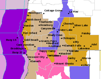
A Winter Weather Advisory remains in effect from 10:00 a.m. Friday morning through 10:00 a.m. Saturday morning for the south-central Oregon Cascades and Siskiyou Mountains, including Crater Lake and Diamond Lake.
Forecasters at the National Weather Service said snow and blowing snow above 4,500 feet is expected. Total snow accumulations of 6 to 12 inches. Winds are expected to gust between 40 and 70 miles per hour over exposed terrain. Localized blizzard conditions are possible at times, especially at and above tree lines.
The Advisory area includes highways 138, 230, 62 and 140. The heaviest snow is expected from 10:00 p.m. Friday through 8:00 a.m. Saturday.
Forecasters said holiday travel is likely to become difficult at times. Drivers should plan for snow on roads and prepare accordingly by traveling with a 4-wheel drive vehicle and/or with snow tires while carrying tire chains. Snow and blowing snow will reduce visibilities to a quarter of a miles or less at times.
3 to 7 inches of snow is expected on Interstate Five on the Siskiyou summit. Snowfall rates could be up to a half inch to one inch per hour, and at times could impact travel.